Product Catalog
Browse through our array of projects
- None
Project Description
As part of the African Adaptation Project on climate induced flood and drought risk maps for 5 floor prone districts in the country. The consultancy service provided by CERSGIS has resulted in the ability of the districts to know their spatial flood and drought risk profiles. Developed flood and drought risk maps for 5 districts in the country using GIS based multi criteria evaluation. • Organized district workshops and validated drought risk maps in 5 districts. • Trained district stakeholders in GPS field mapping and data collection.
-
Client
NADMO/UNDP
- None
Project Description
The IITA-STCP Ghana was interested in exploring the possibility of mapping cocoa farms with GPS technology, and developing a GIS database for a pilot area in the Ashanti Region Kuapa Kokoo Farmers Union (KKU) was identified for the pilot. This project employed GPS and GIS analysis tools for mapping cocoa farms and developed a prototype GIS database for KKU.
-
Client
IITA-STCP Ghana
- None
Project Description
CERSGIS assisted Plan Ghana in evaluating existing data management structures within Plan Ghana Data collection instrument design and development, training of data enumerators on questionnaire administration and GPS usage, supervision of GPS survey of water and sanitation facilities in the plan Ghana Staff on the use of GIS-based Water and Sanitation MIS developed. Evaluation and review of existing data management regime within Plan Ghana • Needs assessment and determination of water and sanitation data requirements • Data collection instrument design • Participatory rural appraisal and focus group interviews • Water and Sanitation MIS Database Design and implementation • Capacity building of Plan Ghana Staff on the use of GIS-based Water and Sanitation MIS developed.
-
Client
Plan Ghana
- None
Project Description
The Project is a development of an online Geographic Information System database of all planned infrastructural development for the country. It is based on the National Infrastructure Plan developed by the NDPC. The platform shows the distribution of these projects across the country and their projected economic benefits after implementation. This allows for the spatial analyses on the data by decision makers and all other stakeholders. It also makes available socio-economic indicators as base maps for almost all analyses. Development of an integrated GIS database for all NIP projects in Ghana • Development of a web portal to host the platform. • Programming of interactive map interface and upload of GIS data using ArcGIS online. • Commissioning and Training of stakeholders on the use of the online GIS platform. • Platform Maintenance and periodic updates.
-
Client
Development Partners , MMDAs and General Public
- None
Project Description
The objective of this project is to provide decision-makers and opinion leaders from different sectors in Ghana with critical preliminary information and analysis on opportunities for restoration of lost forests and degraded lands as a basis for national REDD-plus strategies within the context of multifunctional land use. National Stakeholder • Forest cover mapping • National Land use/Land cover mapping. • Regional Validation Workshops • Report writing.
-
Client
The Program on Forests (PROFOR)
- None
Project Description
Training of 56 TCPD Professional Planners in Project Management and LUPMIS using Map Maker Software Installed at CERSGIS Training Laboratory.
-
Client
Ministry of Local Government, Rural Development and Environment
- None
Project Description
The CBRDP was funded by the International Development Association (IDA) of the World Bank Group, Agency Francais de Development (AFD) and the Government of Ghana (GOG) and has the Ministry of Local Government, Rural Development and Environment as the lead implementing agency. The overall goal of the project was to reduce poverty and enhance the quality of life of beneficiary rural communities. The project objective was to strengthen the capacity of rural communities to enhance their quality of life by improving their productive assets, rural infrastructure and access to key support services from private and public sources. Eco-tourism was one of the poverty alleviation strategies identified to promote improved livelihoods as such CERSGIS was asked to undertake a study to develop management plans for the above identified sites. Reviewed current approaches and strategies for developing and implementing interventions for five pilot watershed sites and six community initiated eco-tourism sites. Proposed new alternative natural resource management activities for CBRDP. Image to Image rectification, Interpretation, Field Reconnaissance visits, Image classification and Analysis, Field validation and Stakeholders sensitization Campaign and collection of in-depth Information on six watershed sites.
-
Client
Ministry of Local Government, Rural Development and Environment
- None
Project Description
In support of the Government of Ghana’s Highway Sector Investment Programme, the Government of the United Kingdom, through the Department for International Development (DFID), provided a grant for a Rural Feeder Roads Programme that will be executed by the Department of Feeder Roads (DFR) of the Ministry of Roads and Transport (MRT). An inventory system and road database to aid in road maintenance planning.
-
Client
DFID//Department of Feeder Roads
- None
Project Description
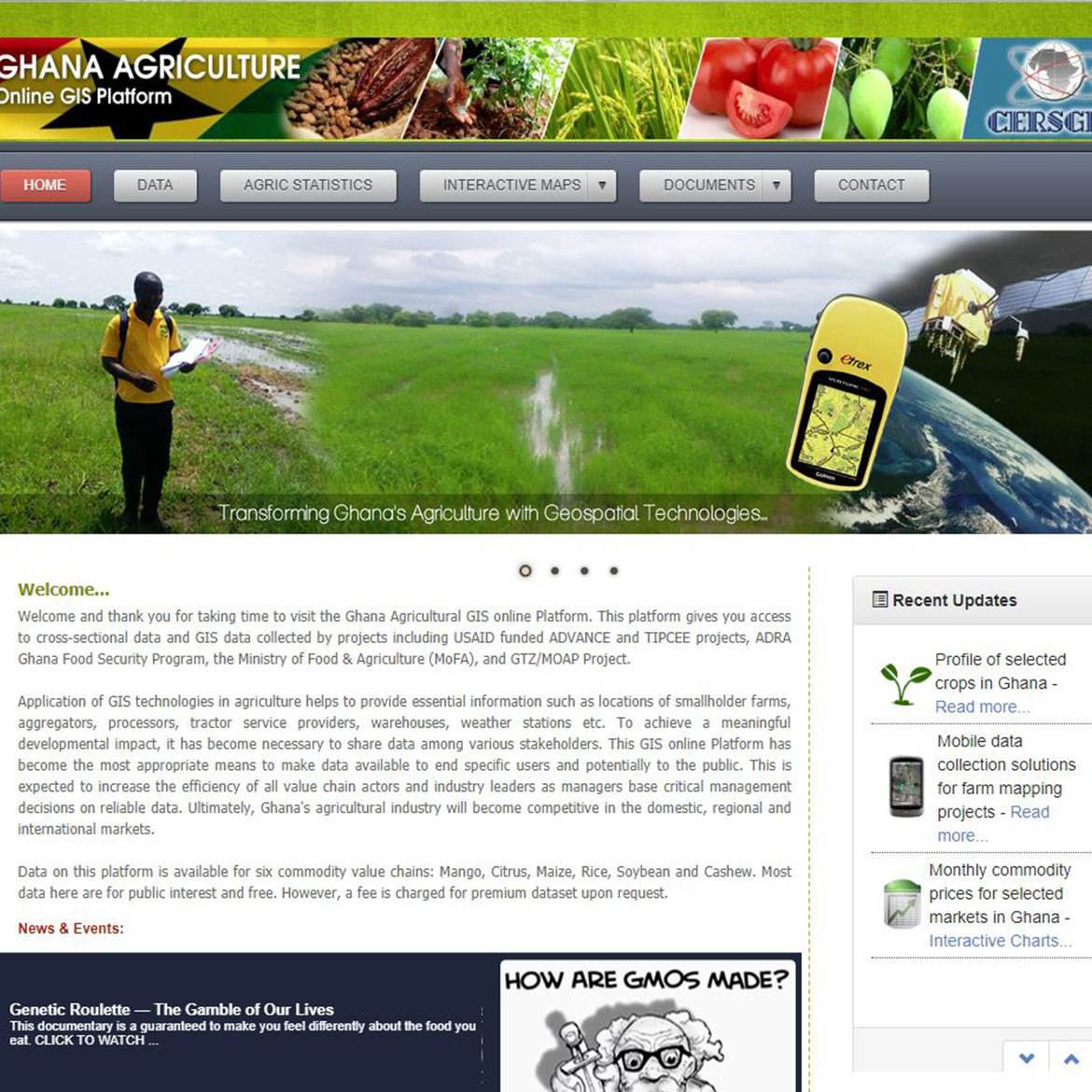
The goal of this initiative is to help fill the data gap in Ghana’s agriculture transformation. Users to the online platform will be able to access agriculture related geospatial data needed for specific agricultural related projects. This will serve as repository of all agriculture related geospatial dataset in the country. Development of the web-based platform • Publicize the online platform • Train users • Update the portal periodically.
-
Client
Development Partners and Decision makers in the Agric industry
- None
Project Description
The objective of the Transport Sector Project for Ghana was to improve mobility of goods and passengers through reduction in travel time and vehicle operating cost, and to improve road safety standard. The assignment was to develop a GIS Centre at the Ministry of Roads and Highways and managed by Research, Statistics and Information Management Directorate. The GIS-T would be used for a wide variety of transport- related applications for planning, monitoring, evaluation and reporting. Acquiring and Processing- geospatial data • Analysing and Interpreting- to deliver business critical information • Formatting and Managing- presenting data in a form usable by clients for their business • GIS Designing and System Development- developing software system for the analysis, management and integration of geographic data into business processes. • Hosting and Delivering- Implementing of technologies and developed system to enable geospatial data to be easily managed, while providing for rapid delivery.
-
Client
Ministry of Roads and Highways
- None
Project Description
The Ghana Revenue Authority has a mandate to identify all tax payers in the country and through effective tax regime, collect revenue for the state. To widen the tax net and improve the tax administration, this system is to help identify all the potential tax payers across various tax districts. As part of this assignment, the Ghana Revenue Authority procured the development of a Geographic Information Systems (GIS) based planning, monitoring, reporting and evaluation database application to tax administration. GPS data processing • GIS Database Development • GIS/GPS Training of Project Staff • Web application development.
-
Client
Ghana Revenue Authority
- None
Project Description
In 2006, Ghana Government signed a $547 million contract with the Millennium Challenge Corporation (MCC) of the United State of America aimed at reducing poverty through economic growth and agricultural transformation. The project is operational in 23 project districts and is implemented by the Millennium Development Authority (MiDA). To assist MiDA and its partners in easily accessing and managing a centralized database, perform spatial analysis and reporting for effective monitoring and evaluation of activities, a GIS-based database application was implemented. Design and deploy a GIS-based centralized Information Management System that would capture and streamline regular spatial data updates from the various MiDA projects • Develop a standardized data format for conducting spatial analysis and output requirements for monitoring project activities • Implement visualization tools that link the database for mapping the spatial distribution of features • Field data capture, validation and processing • Determine spatial data requirements as well as attributes for all relevant thematic layers • Preparation of training manuals and train project staff for optimal use of the application • Report Writing.
-
Client
Millennium Development Authority (MiDA)
- None
Project Description
Cocoa Life is a Cocoa Sustainability program initiated by Mondelez International. We profiled and mapped farmers and their farms respectivily using handheld GPS devices and created spatial database on the bio-data of farmers, farm ownership and farm sizes which will be used by Mondelez International for their operations. The purpose of the project is • To build a spatial database • To provide relevant information to support the entire cocoa life program.
-
Client
Mondelez International

- None
Project Description
The Ghana Environmental Resource Management Project (GERMP), executed between 1993 and 1998, under the coordination of Environmental Agency funded the development of a land cover/land use map of Ghana at the scale of 1:250,000 using satellite imagery acquired for 1990-1991. There have been considerable changes in the landscape since 1990 as a result of the very dynamic nature of land use in Ghana, necessitating the updating of the land cover/land use data. This project was proposed to update the existing, land cover/land use map, under the Natural Resource Management Project (NRMP) using up-to-date satellite imagery. It was required also to develop information on land use change trends using the two land cover/land use datasets. The Coordinating Agency of the Project was the Environmental Protection Agency. Satellite image based Land use mapping • Field verification and validation • Stakeholders sensitization Campaign and collection of in-depth Information on Land Use for assessing State of the Environment • Development of National Land use and land cover Database. • Map production and Generation of Statistics.
-
Client
Ministry of Lands and Forestry
- None
Project Description
Sunshine Technology was interested in forestry and bio-energy projects that have the potential of being commercially viable and which can also generate carbon credits under the Kyolo Protocol Clean Development Mechanism (CDM) and other carbon crediting systems. To determine the viability of project sites, Sunshine Technology has environmental, social and terrain requirements to be met. This project therefore employed GIS analysis tools in ascertaining the level of suitability of each area based on a user-defined criteria. Satellite image preparation, processing and land use classification • Field data capture, collation and validation for Land cover/Land use map production • Suitability multi-criteria generation and implementation in GIS • Digital Terrain Modeling, visualization and characterization of site • Image statistics retrieval, analysis and optimization for suitability indicators • Production of 3D suitability maps and indices showing degree of suitability.
-
Client
Sunshine Technology
- None
Project Description
The Government of the Republic of Ghana (GOG) in line with its Poverty Reduction Strategy is pursuing a compressive Poverty Reduction Programme. In support of this the Government of Ghana through the Ministry of Local Government and Rural Development with the Social Investment Fund as the implementing agency, embarked on a five-year Urban Poverty Reduction Project (UPRP) which aimed at contributing to Ghana’s efforts to achieving the MDGs. The assignment covered the implementation of capacity building activities aimed at strengthening pro-poor strategic urban development planning at the local level. Installation of GIS-based Urban Development Planning software.
-
Client
Ministry of Local Government and Rural Development, African Development Bank
- None
Project Description
The Ghana Energy Development and Access Project (GEDAP) assisted Government of Ghana in improving the operational efficiency of the electricity distribution system and increasing the population's access to electricity. Additionally the project was aimed at transitioning Ghana to a low-carbon economy through the reduction of greenhouse gas emissions. The Application is to be used for Geographic Information Systems (GIS) based planning, monitoring, reporting and evaluation database application to facilitate implementation of the GEDAP.
-
Client
Ministry of Energy
- None
Project Description
As part of UNDP-Sierra Leone funded programme on strengthening Electoral Management capacities CERSGIS was contracted by the National Electoral Commission (NEC) of Sierra Leone to develop and implement a GIS based Mapping and Spatial data Management System as part of its five years strategic plan. The consultancy service provided by CERSGIS has resulted in the ability of NEC to use GPS to capture data and process the data to develop an electoral geo-database useful for planning, monitoring and evaluation of electoral resources.
-
Client
National Electoral Commission (NEC) of Sierra Leone
- None
Project Description
Map conceptualization and digital map production of District: Optimum accessibility maps Composite poverty maps spatial distribution of infrastructural facilities. Database Design and development, Map production.
-
Client
GTZ
- None
Project Description
The project was for the development of a Geographic Information System for Cocoa Swollen Shoot Viral Diseases Control Unit (CSSVDU) Control Programme, a request that originated from the Project Management Unit (PMU) within the Cocoa sector Support Programme. The CSSVDU was responsible for providing extension services for the management and control of Cocoa Swollen Shoot Viral disease in the cocoa growing areas of Ghana. User Requirement Survey & Procurement • On-Site crash programme on the use of the PC • Prototype database development • System Design and Specification • Strategic level Education • Tactical Training • Operating Training • Procurement and Installation • System’s operation for the data conversion • Regional Installation and start-up activities • System Maintenance/Capacity/Capability Enhancing Plans • Commissioning
-
Client
EU. Ministry of Finance & Economic Planning/Cocoa Swollen Shoot Viral Diseases Control Unit of the Cocoa Services Division
- None
Project Description
As part of the electoral commission’s programme on strengthening Electoral Management capacities CERSGIS was contracted to develop and implement a GIS based Mapping and Spatial data Management System. The consultancy service provided by CERSGIS has resulted in the ability of the EC to use GPS receivers to capture data and process the data to develop an electoral geo-database useful for planning, monitoring and evaluation of electoral resources. Trained regional and district electoral officers from all regions of Ghana in the use of GPS receivers for mapping. • Facilitated the design and development of a customized database application for capturing, maintaining, analyzing and presenting election data at political administrative levels. • Developed an interactive web-based results map of 2004, 2008 and 2012 presidential and National Electoral Commission of Ghana.
-
Client
National Electoral Commission of Ghana
- None
Project Description
The Ghana Capacity 21 Programme (Development of District Environmental Resource Information System) aimed at strengthening the capacities of national institutions involved in environmental and development planning to support district, regional and national planning in a sustainable manner. It also aimed at strengthening the role of science and technology for sound environmental and natural resource management. To achieve these aims the programme required technical assistance to plan, monitor and evaluate development and environmental projects and also develop expertise in the application of remote sensing and geographic information systems for determining and identifying optimum criteria for effective development and environmental planning. Need assessment and equipment Specification • Preparation of Training Manuals • District Environmental Resources Profile and Spatial Database Development • Training of Project Staff.
-
Client
UNDP/Government of Ghana
- None
Project Description
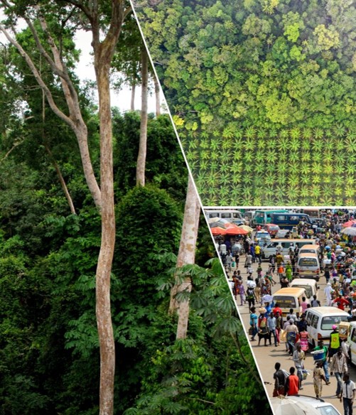
The current trend of land degradation and unsustainable land management in Ghana negatively impacts rural land use, productivity and security of ecosystem functions as well as the integrity of the continents ecosystem for a long time. Scaling up sustainable land management programmes was deemed necessary to reverse the trends of land degradation. The national sustainable land management committee instituted by the Environmental Protection Agency of Ghana therefore requested the services of CERSGIS to carry out a GIS database development of maps and analysis of remote sensing satellite imagery to determine and monitor desert prone areas in the ecological zones of Ghana. GIS analysis of environmental indicators for mapping degraded areas • Preparation of desertification hazard map to appraise government and the public on the magnitude of desertification or land degradation problems.
-
Client
Environmental Protection Agency
- May 3, 2021
Project Description
The Ghana Land Use Project (GALUP) will enhance the current operational planning framework and building capacity for effective land use planning in Ghana. Working in close collaboration with national and regional authorities in Ashanti, Eastern and Central Regions in Ghana, the project aims to build local capacity in the region regarding remote sensing and GIS, and transfer the land use planning framework for continued planning. The GALUP project has been awarded by SERVIR, a joint venture between NASA and the U.S. Agency for International Development to help developing countries use Earth-observing satellites and geospatial technologies for managing climate risks and land use. It is led by Professor Jasmeet Judge in the Agricultural and Biological Engineering (ABE) Department at the University of Florida (UF), in collaboration with researchers from UF, the Centre for Remote Sensing and Geographic Information Services (CERSGIS) in Ghana, and the University of Ghana (UG).
-
Client
SERVIR
- Nov. 2, 2020
Project Description
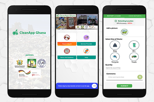
CleanApp is a portal designed to be used to collect and manage solid waste management in Ghana. The application comes in four components which includes; Mobile Application, USSD platform, Web information portal and Backend.Individuals can request solid waste collection in their homes or neighbourhood on the platform and as well contact sanitation service providers. Users can get useful information on Solid Waste Management in videos and articles, and locate available solid waste containers around them using the mobile application.
-
Client
GSS, GIZ

- April 1, 2020
Project Description
The National Development Planning Commission Act, 1994 (Act 479) and the National Development Planning (System) Act, 1994 (Act 480), provide the core legal framework for the establishment of the Commission and the performance of its functions. An authoritative planning body providing sound policy choices for sustainable and even development of Ghana. Its mandate is to advise the President of the Republic of Ghana (and Parliament on request) on national development planning policy and strategy by providing a national development policy framework, preparing and ensuring effective implementation of approved national development plans and to coordinate economic, and social activities country-wide in a manner that will ensure accelerated and sustainable development of the country to promote continuous improvement in the living standards of all Ghanaians. NDPC partnered with CERSGIS to develop their web portal to showcase all the developmental projects going on in the country and other useful information.
-
Client
NDPC
- May 8, 2019
Project Description
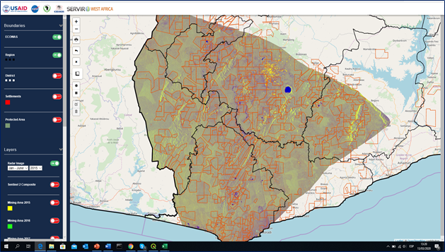
A joint initiative of the National Aeronautics and Space Administration (NASA) and United States Agency for International Development (USAID), and leading geospatial organizations in Asia, Africa, and Latin America, SERVIR partners with countries and organizations in these regions to address critical challenges in climate change, food security, water and related disasters, land use, and air quality. Using satellite data and geospatial technology, SERVIR co-develops innovative solutions through a network of regional hubs to improve resilience and sustainable resource management at local, national and regional scales. SERVIR increases awareness and access to information and supports analysis to help people in these regions through early action and the use of Earth observation information, Earth science, and technology. In respect of that, artisanal mining and charcoal production has been a major interest to SERVIR West Africa. As part of its target to bringing solutions to areas such as food security, water resources, land use change, and natural disasters, it seeks to consider investigations into artisanal mining and charcoal production in Ghana and wants to use earth observation tools and technology to easily monitor its growth and to further find ways to curb the troubles it has caused and will cause in future. It does this also, by entering into a collaboration with Center for Remote Sensing and Geographic Information Services (CERSGIS) to build web portals to track the activity across the country.
-
Client
SERVIR - WEST AFRICA
- April 1, 2017
Project Description
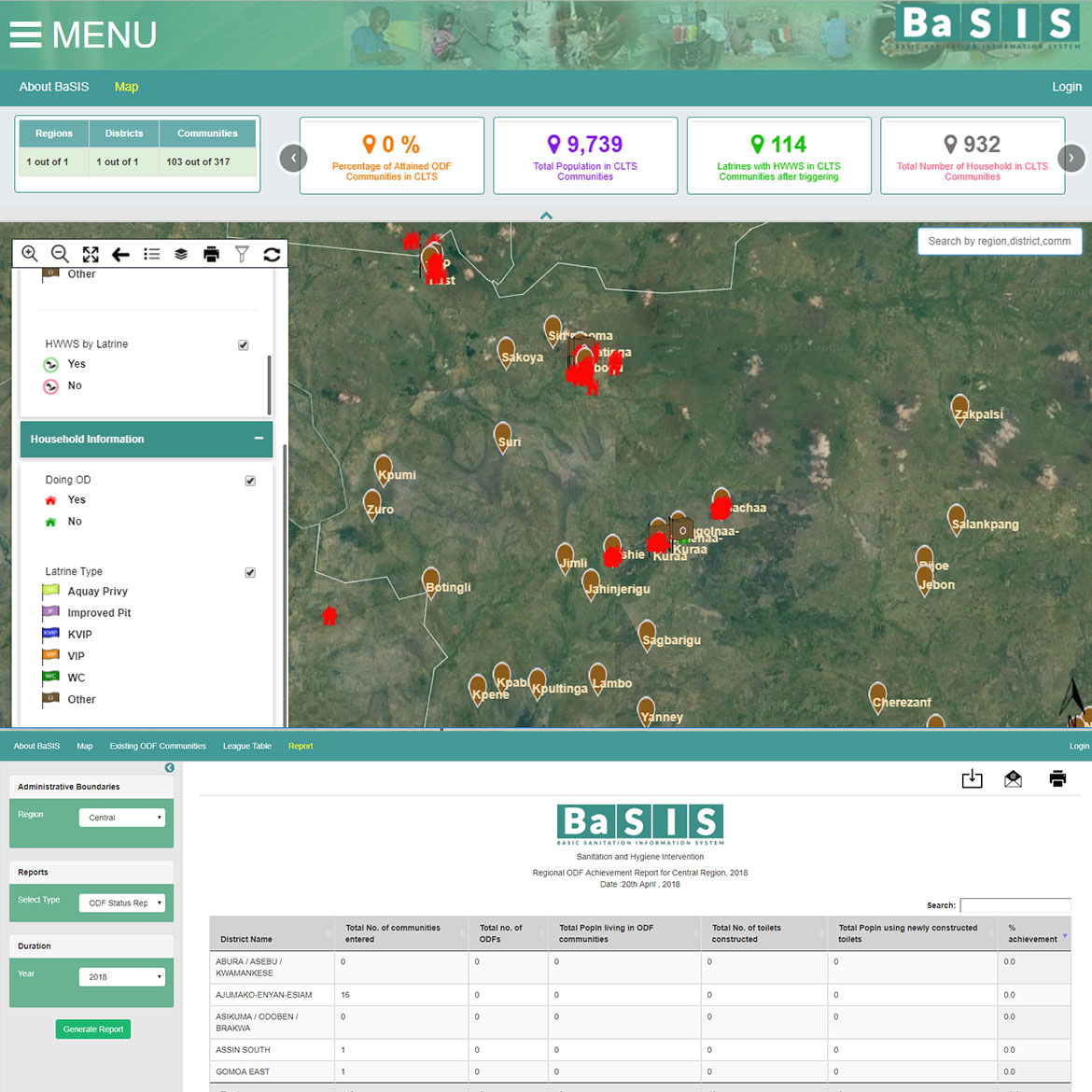
BaSIS - is a decentralised M & E sanitation system developed to aid in the implementation of the CLTS (Community-Led Total Sanitation) at both sub-national and national levels. The system is basically built to provide GIS-based data and information along the implementation of CLTS by field facilitators. Data collected and submitted with the BaSIS mobile data collection app is visualized as maps, charts and tables on the platform.
-
Client
UNICEF
- Jan. 1, 2016
Project Description
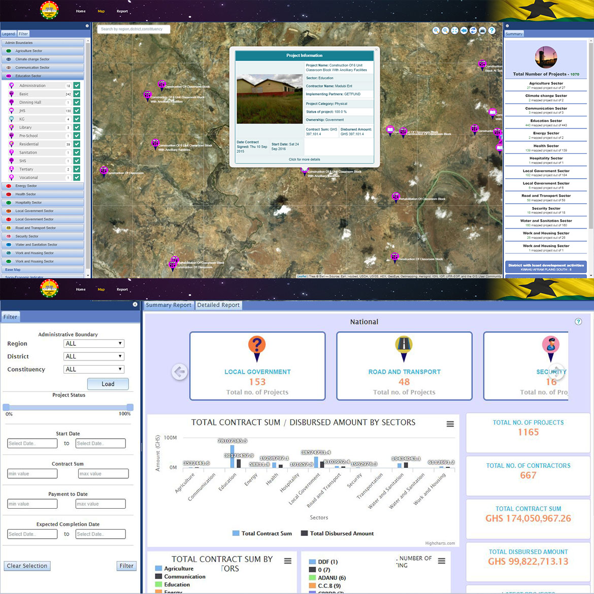
The objective of this platform is to provide credible spatial data on development activities within districts (currently piloting 30 districts) to enhance the monitoring and oversight responsibilities of parliament of Ghana with respect to development activities in the country. The project aims at developing a spatial database and a web application for development activities in Ghana.
-
Client
Parliament of Ghana and African Development Bank
- Dec. 31, 2015
Project Description
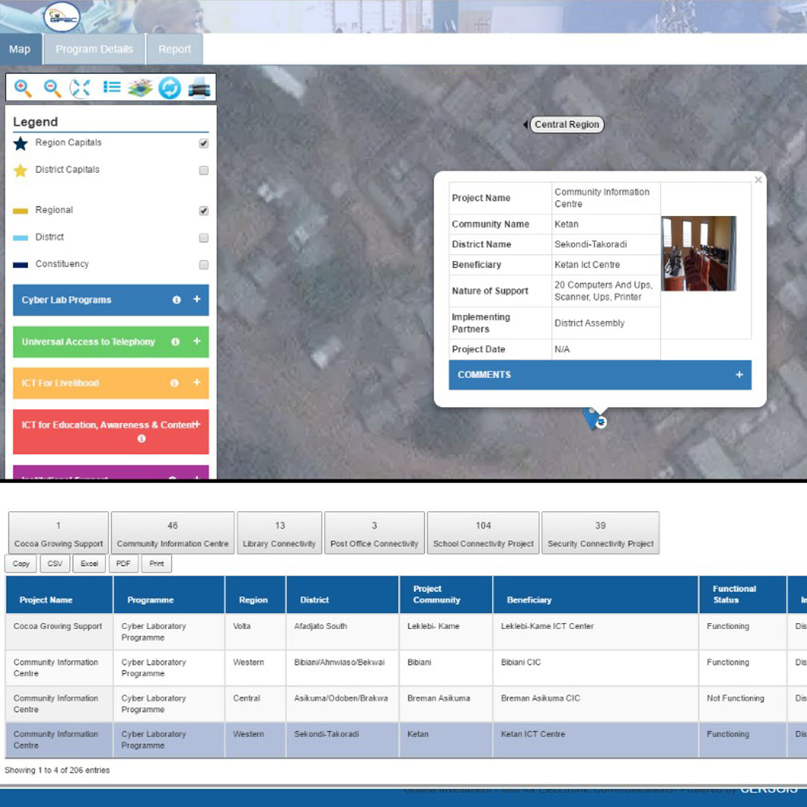
Ghana Investment Fund For Electronic Communication (GIFEC) contracted CERSGIS do a comprehensive digital mapping of all its project sites in to M & E application for hosting on its web portal for easy access by organizations and individuals. The objective of the project is to improve access to information to the general public and other key stakeholders. Specifically, the project seeks to achieve the following: * Provide real time information and data to the general public * Create opportunities for partnerships and linkages with other organizations * Facilitate effective monitoring of GIFEC projects * Ensure effective utilization of the GIFEC webpage.
-
Client
GIFEC
